Improving the Performance of Radar Systems with the Help of Digital Inclinometers
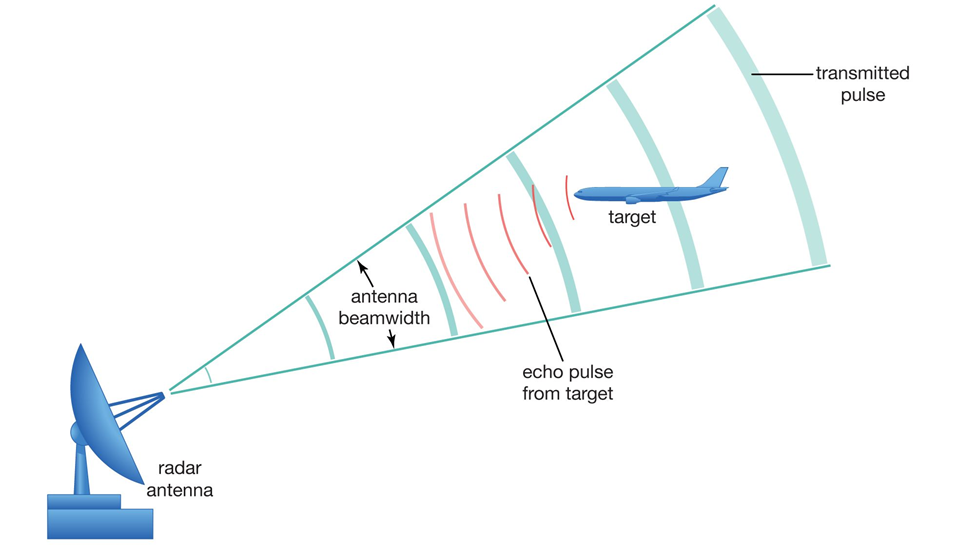
As we know, digital inclinometers measure the angle or inclination of an object with respect to the plane of gravity, and therefore can provide accurate data about the orientation of the antennas of a radar system, which is used to ensure accurate identification and tracking.
In general, the use of digital inclinometers can significantly improve the accuracy and reliability of radar systems. In this article, we will have a brief look at how to use digital inclinometers in radar systems and its role in improving the performance of these systems.
1- Enhanced Angle Correction
Dynamic Adjustments:
Inclinometers can continuously monitor the tilt of the radar system. This allows for real-time adjustments to the radar beam’s angle, ensuring optimal performance regardless of environmental factors such as wind or vibration. Digital inclinometers are a major component of the boresight alignment kit.
Tilt Compensation:
Data from the inclinometer can be used to correct for any tilt in the radar system, which could otherwise lead to errors in target acquisition and tracking.

2- Improved Target Tracking
Accurate Azimuth and Elevation Angles:
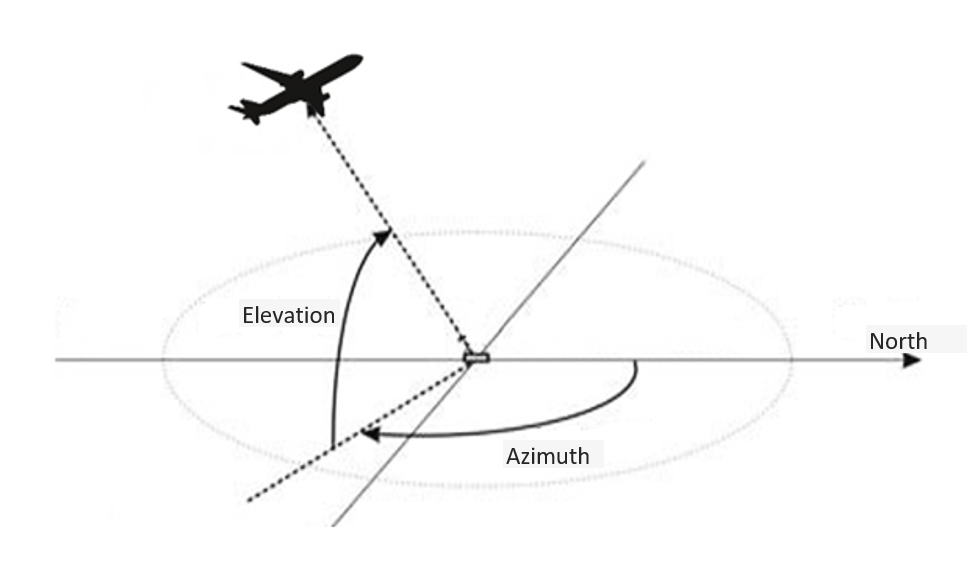
By integrating inclinometer data, the radar can maintain accurate azimuth and elevation angles despite any shifts or movements in its position.
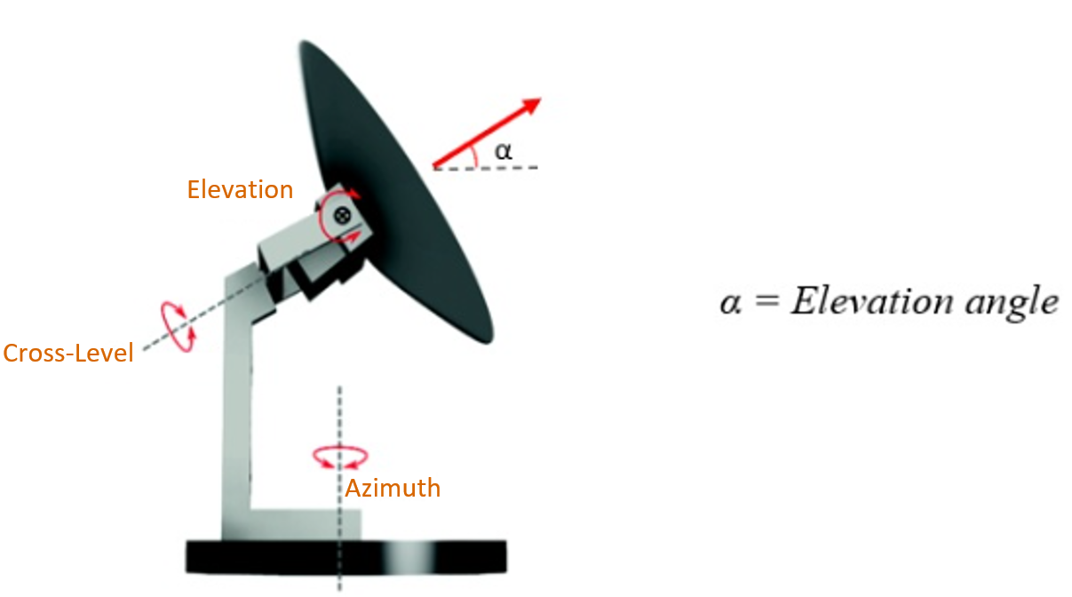
In a radar system, the importance of controlling the elevation angle is more than the azimuth angle. First of all, it should be noted that the higher the angle of elevation, the more the radar can cover a greater height in a shorter horizontal distance. Since the radar designer usually knows the range of height and horizontal distance of the target object (such as airport radars), the radar system usually rotates the azimuth in 360 degrees in a fixed elevation angle. In order to accurately control and determine the elevation angle, a static inclinometer sensor can be installed in the base part of the antenna (Antenna Pedestal) so that the radar controller can control the α angle by receiving information from the inclinometer sensor.
Enhanced Stability:
This leads to increased stability in tracking fast-moving targets, especially in dynamic environments such as maritime or aerial surveillance.
3- Geolocation Accuracy
Post-Processing Corrections:
When processing radar data, inclinometer readings can be used to correct geolocation algorithms, thereby improving the accuracy of target positioning.
Integration with Other Sensors:
Inclinometer data can be combined with other sensor data (e.g., GPS, gyroscopes) for more precise location and movement tracking.
4- Support for Mobile Applications
Adaptability:
For radar systems mounted on vehicles or aircraft, digital inclinometers can help adjust for terrain changes, ensuring consistent performance even in rough environments.
Self-Leveling Capabilities:
Advanced systems can utilize inclinometer data to self-level, which is especially beneficial for radar systems on unstable platforms.


5- System Health Monitoring
Condition Monitoring:
Continuous inclination monitoring can serve as an indicator of the system’s physical state. Drastic changes in inclination could signal issues such as mounting failure or structural integrity threats.
User Alerts:
Systems can be programmed to alert operators if the inclinometer readings exceed pre-set thresholds, prompting maintenance before performance degrades.
6- Increased Operational Range
Tilted Terrain Navigation:
Inclinometers can also help radar systems adjust for obstacles or tilted terrain, enabling operations in challenging environments where traditional radar systems might struggle.
Optimized Coverage:
The ability to dynamically adjust the radar signal path based on inclinometer data can optimize coverage area, reducing blind spots.
7- Integration and Calibration
Seamless Data Integration:
Ensuring the inclinometer is integrated into the radar control systems for smooth data flow and usage.
Calibration Procedures:
Establishing calibration protocols between the radar and the digital inclinometer to ensure accuracy across varying operational conditions.
Conclusion
All in all, the integration of digital inclinometers in radar systems can lead to significant improvements in their performance, reliability and accuracy. To improve the performance of radar systems, it is important to pay attention to several points:
- To obtain a single reference, the local terrain must be measured and reported to the radar processing system at the time of the deployment of the radar system.
- The system must be continuously monitored during its operational period because external factors such as ground subsidence can also change the radar reference level, which collectively make the data from one radar to be less valid than another.
- Radars undergo severe temperature changes due to exposure to direct sunlight, and due to phenomena, such as thermal buckling, their reference level will move.
For this reason, for better monitoring of the radar antenna as well as compensation for the error caused by external factors, inclinometers with high temperature compensation as well as suitable measurement range and accuracy are usually used, instead of systems such as Shaft Encoder, because the use The inclinometer allows the operator to continuously monitor the system in addition to controlling the side and height angles and compensate for phenomena such as thermal buckling and errors caused by external factors. This synergy Technologies not only improve operational efficiency, but also increase situational awareness in real-time monitoring and surveillance applications.


